
Introduction
The petroleum sector in Venezuela is opening up to investment free of the threat of US sanctions for the first time in two decades. Companies seeking investment opportunities, whether they are re-entering the country to regain assets they previously held or to enter new acreage; or whether they are entering for the first time, face one significant common hurdle: accessing, collating and analyzing the data necessary to back an investment decision.
For companies re-entering, skillset & knowledge-based attrition and database corruption will have resulted in the loss of corporate knowledge. For new entrants, access to reliable data of any sort will be problematic.
U3 Explore offers a suite of products to help companies overcome these challenges, and a group of skilled and experienced professionals to both deploy them and, for companies lacking the critical skillsets, to assist with the necessary analyses.
The Opportunities
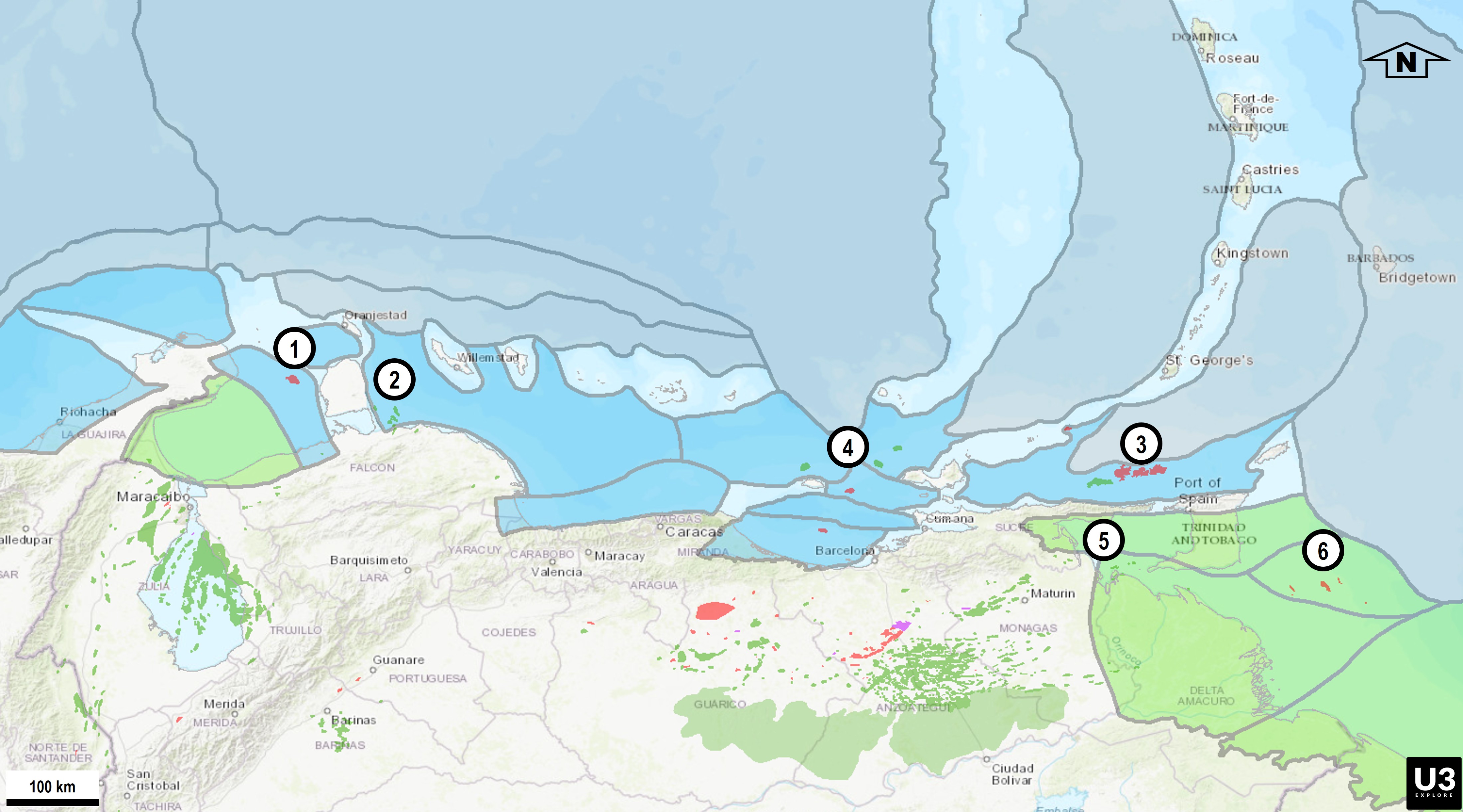
The re-opening of Venezuela presents important opportunities in the upstream energy sector, in four major subsurface segments:
- Greenfield Exploration for gas and liquids in immature/frontier offshore basins.
- Brownfield Production of light, medium and heavy crudes and gas.
- Exploration in the extension of current discoveries and undeveloped plays in mature basins
- Massive development of the extra-heavy Orinoco Oil Belt.
Further opportunities exist in a number of other areas:
- The surface realm with the reconditioning/replacement of production, transportation and upgrader facilities.
- Data collection and reprocessing.
- Data organization, storage and analysis.
The Historical Problem
Over the course of the 20th century, a world-class petroleum industry evolved in Venezuela which was administered after the nationalization in 1975 by PDVSA and its subsidiaries. Since full nationalization of assets in 2007 PDVSA has been the controlling entity.
As the industry expanded and technologies and concepts evolved, a significant legacy of technical literature and production data was generated on basins, fields and reservoirs whose geological complexity emerged over time. Because asset ownership, regulatory requirements, asset definitions and production reporting also evolved over time, coherent data on any given asset is difficult to obtain and indeed may not even be available within the current incarnation of PDVSA given the erosion of capability in the organization. Matters are further complicated by the fact that such data as are available from a wide variety of public sources are often categorized by practical but not necessarily geological criteria, related, for example, to common production facilities rather than subsurface reality.
The results of this complex history are fragmented data, inconsistent geological definitions and ambiguous production reporting, even from modern data repositories. As a result, analytical and modelling work to assess the potential value of any given asset will entail significantly more uncertainty than would generally be encountered, particularly when considering access to brown-field assets.
The U3 Explore Solutions
U3 Explore has resolved these data and information-related constraints by collating legacy petroleum information into a curated, geologically coherent, AI-ready framework.
As detailed below, we took a number of important steps to validate a very large volume of publicly-available information and integrate it with U3-proprietary databases. We utilized a number of tools to give those database a context within which the analysis necessary to make informed business decisions can be made.
U3 Explore supports exploration of offshore and onshore basins through integrated basin and play classification, granular geospatial mapping, global analogue benchmarking, extensive gravity datasets and geochemical integration.
We support investment decisions on brownfield assets with extensive, geologically curated production datasets at field and flow unit levels to deliver statistically defensible subsurface intelligence with a geologic rather than geographic/administrative basis.
Investment in U3’s products will deliver accelerated due diligence, reduced technical risk, clearer reserves volumetrics, and visualization of hidden opportunities, enabling investors to move from raw data to informed, confident capital allocation decisions.
1. Transforming Fragmented Legacy Data into Useable Intelligence
Abundant geotechnical and volumetric data and information are publicly-available in scanned documents and hardcopy archives of reserves books, regulatory reports, SEC filings, academic theses, technical publications and private libraries. Much of it, however, is inconsistent, incomplete, or tied to outdated coordinate systems. In the absence of a unified geological schema applied to the entire datasets, resource and production figures cannot be compared, aggregated, or validated in a statistically meaningful way and therefore cannot be modelled with any acceptable degree of uncertainty.
U3 Explore has addressed this challenge through a rigorous and structured information recovery and validation process wherein hardcopy materials were identified, scanned, and converted into consistent, QC’d structured digital datasets, for example raster tables were compiled into analytics-ready Excel formats and maps geospatially-rectified.
2. Assuring Geospatial Accuracy
The majority of publicly available field maps sourced for this study originated from publications produced decades ago and later re-scanned or modified without positional verification, and it is clear that in some instances structural elements such as faults were added without documented geodetic control. As a result of these inaccuracies in field polygons, well positions and oil and gas field boundaries were not consistently spatially-registered which directly affects production aggregation, volumetric calculations, and asset valuation.
U3 Explore resolved this issue by undertaking comprehensive geospatial recalibration in to standardized coordinate systems such as WGS84. Producing and non-producing basin boundaries were defined/updated and integrated in accordance with tectonic and stratigraphic criteria, consistent with the regional geodynamic framework developed by U3 using proprietary tools and data.
Field outlines from public sources across Venezuelan basins were re-digitized, and alignment with official production data and expert review by Venezuelan subject-matter specialists. Simultaneously, production records were cross-validated as far as possible against published sources and well-specific information and thousands of exploration well locations originally documented only in scout archives were digitized and incorporated into a coherent framework.
This recalibration restores spatial integrity and enables statistically valid aggregation of production and resource data, and fragmented legacy material was transformed into curated, decision-grade information.
3. Validating Field Volumetrics and Brownfield Extension Potential
Reportage of field volumetrics within PDVSA evolved to reflect a combination of administrative areas around centralized facilities or gathering-stations and individual producing units often unrelated to reservoir stratigraphy. Reservoir intervals are often classified by age alone rather than by play system. Stacked plays within a single producing area may not be formally distinguished. Thus, volumetric reports often aggregate multiple geological accumulations under a single field name, despite representing separate structural or stratigraphic entities, or on the other hand may divide a single geological accumulation into several producing units based on license block areas.
These inconsistencies distort decline analysis, EUR forecasting, reserves classification and redevelopment planning.
The lack of geological context is particularly significant in terms of understanding reserves extension potential. Venezuelan fields commonly contain stacked plays, yet reservoir intervals are rarely assigned to specific play systems making it difficult to evaluate upside in the absence of contextual structural trends, migration pathways or fairway continuity. As a result, remaining resources can be underestimated, EUR methodologies do not account for reservoir heterogeneity, and reservoir management optimization may be hampered. U3 EXPLORE resolves this by defining consistent play fairways classified by.
U3 Explore has addressed these volumetric and upside issues by reclassifying producing units within play-fairway-defined (structure, lithology, trap type, and petroleum system elements) and geospatially registered frameworks. Field definitions have been recalibrated to honor geological boundaries rather than administrative criteria, flow units assigned to tectonostratigraphically consistent plays, and production data reorganized within this context, enabling statistically defensible analytics.
This play-based framework provides a foundation for distinguishing between resources and reserves, a prerequisite for credible capital deployment.
Client Utilization of U3 Explore Tools
In order to make capital commitments to brownfield projects, decision-makers need knowledge that is not easily derived from the raw data available because of the issues noted above.
In hierarchical context, this knowledge can be summed up as:
- Basin- and play-scale geological context, which leads to…
- A clear understanding of petroleum system controls, which provides…
- Geologically consistent field definitions, which in turn underlie…
- Accurate and transparent production allocation, which is the basis of....
- Statistically defensible reserves and resource classification
In the absence of this foundational knowledge, valuation risk increases, capital efficiency declines, and production and exploration strategies lack technical defensibility.
For exploration and production assessments, U3 Explore has collated Venezuela’s extensive publicly-available datasets, which combined with our affiliates’ deep subject-matter knowledge has delivered a solution-set comprising spreadsheets, geospatially-registered maps and databases of geological, geochemical, production and volumetric information.

Our tools deliver:
- On a regional scale, redefinition of petroleum provinces and geologically consistent basin outlines utilizing in-house (proprietary) gravity, geochemistry, and tectonic models.
- At the local level, expert classification, validation, and contextual organization of legacy information into geologically-coherent reservoir plays, in order that Production and Reserves volumetrics can be assessed at field and flow unit level with the capability to support additional development plans and economic forecasts.
- Geologically-defined, GIS – based oil gas fields and asset maps to display those data and analyses.
- Global analogue field and reservoir benchmarking.
- Geospatial validation and correction using publicly available data.
The result is a subsurface intelligence platform designed to reduce uncertainty and accelerate investment screening.
Products
- U3D Analog Fields and Reservoir Database (Global dataset and Platform with Venezuela Special edition).
- GIS -based Venezuelan content at Basin, Play and Oil/Gas Field-scale.
- Caribbean Atlas – Tectonostratigraphic basin and play framework.
- Gravimetric database – foundation for deformation evolution in space and time (GIS files).
- Curated production volumetrics and data according to geological insights (Excel for analytics).
- Geochemistry databases (integrated, data available under 3D party licenses).
- Deformable Plate Model using integrated gravity, magnetic and seismic data.
U3 Explore Delivers Strategic Advantage
U3 EXPLORE’s framework moves investors beyond raw data aggregation to structured decision support:
DATA begets INFORMATION delivers INSIGHTS facilitates DECISIONS
By integrating geoscience, analytics, and global benchmarking into a coherent platform, U3 EXPLORE enables investors to:
- Reduce technical and volumetric uncertainty.
- Shorten due diligence timelines.
- Reclassify reserves with confidence.
- Find hidden flow unit, field, and play extensions.
- Optimize redevelopment strategies.
- Benchmark assets against global analogues.
- Improve capital allocation discipline.
Q&A SECTION
Legacy data
Q: What is legacy data in this case?
A: The voluminous data and information in printed anddigital format generated for more than 100 years by government, academia,professional associations, scouts and industry itself
Q: Why is it so relevant? There are many peer-reviewed publications on Venezuela topics produced since the 1920’s.
A: Yes, and yet they represent a small fraction of thetotal, reason being that both government and industry encouraged publications with valuable data to be published through local and regional events for morethan 60 years
Q: Are those publications available?
A: Most are scattered and variably accessible in libraries,physical files and personal collections. Academic theses reside in university libraries and some in digital media but not readily available. Many academic theses in USA universities are available but many others have access restrictions at this time. For this reason, for more than 5 years U3 EXPLORE collected and digitized many printed publications, with a view at digitalization.
Production data
Q: Are there publicly accessible reserves, production andwell data available in public domain?
A: Yes, they were periodically released by official entities, some in printed format and some digital and were collected and compiled by U3 EXPLORE in a period of more 5 years during and after the pandemic.
Q: There are datasets for sale from occasional vendors withfull production data by field and reservoir. Shouldn´t those be sufficient tobuild production forecasts?
A: For some cases the answer is yes, but in the mostprolific regions, production is often reported by administrative divisionand/or production facility. For this reason, analysts may end up assessing administrative entities as opposed to geologically defined volumetric accumulations.
Q: Oil and gas fields should be defined by geological criteria for production forecasts apply to realistic volumetrics. What was done previously about it?
A: Previous operators differentiated flow units (reservoirs) through ongoing reservoir analyses. The official production data needs curationto establish geologically-defined reserves volumes.
Q: U3 EXPLORE curatedthat data?
A: Yes. It took five years, and oil and gas field perimeters were geologically adjusted too.
Exploration
Q: Are there exploration opportunities in the mature onshore basins?
A: Yes. In onshore basins there are geologic plays that have not been tested or have not been properly evaluated yet. Some of them are inmature fields, some in the periphery of the basin or in undrilled regions both in Maracaibo and Eastern Venezuela Basin (EVB).
Q: Why are they not mentioned so often in the mainstream industry news?
A: The exploration potential of the offshore basins is large and attracts heavy investors and consequently the attention of specialized publications. On the other hand, additional exploration in the mature onshore basins in the 1980’s and 1990’s resulted in new developments below, beside or near mature oilfields, a strategy that can surely be retaken by a reactivated Venezuelan production industry
Q: What approach should be taken for offshore exploration?
A: There are several offshore basins in immature and early mature stage, most of them with oils and gas discoveries including giant gas and super-giant gas fields. For the less mature basins U3 EXPLORE is developing the CAMGOM project that includes geological update and deformable plate modelling to improve the efficiency of post-1990’s tecto-sedimentary models that for a while have been showing need of new data and updating.
Consulting
Q: All the onshore producing basins and almost all their oilfields are mature. Are there opportunities for improved EUR and incremental reserves are there in mature Venezuelan oil fields?
A: Almost all mature Venezuelan oil fields are still producing, in different stages of development but not depleted. In many ofthem, optimized reservoir management practices and updated technologies can increase EUR and bring about incremental reserves. At U3 EXPLORE we have the expertise in mature Venezuelan oil and gas fields to provide integrated reservoir studies supported by static and dynamic reservoir models.
Q: Surface facilities and infrastructure are key issues at this time. What should operators do about it?
A: U3 EXPLORE has the capability to deploy personnel to assess on the ground existing infrastructure and provide support for optimized field development, integrating surface and subsurface for optimal, cost-effective solutions based on previous knowledge, purpose technologies and best industry practices.
Q: Should environmental liabilities be a cause of concern?
A: Yes. It is well known that for a variety of reasons there are many environmental passives. At U3 we have the capacity to produce environmental base lines and support the relevant environmental permitting in compliance with the environmental regulations of Venezuela.
Origin of data
Q: Can we obtain Venezuelan raw seismic lines and well log curves from U3 EXPLORE?
A: No. The exchange of such data is forbidden by law unless they are accessed through sources in public domain such as theses and technical publications or expressly authorized by the national authority.
Q: Can we obtain Venezuelan processed gravimetric data from U3 EXPLORE?
A: Yes. Multiple datasets acquired by universities for more than 30 years are scattered but in public domain, and we collected, integrated and processed those datasets with one of the main academic promoters of potential fields in Venezuela.
Q: How reliable and complete are Venezuelan technical publications?
A: Very much. There are multiple vintages of high-quality publications about every producing area or region and many of the oil and gas fields in them.
