There is an increasing interest in deep-water exploration for hydrocarbons in the region, and a need to calibrate academic models with new insights from exploration drilling and seismic interpretation to drive successful exploration programs.
Victor Graterol’s Academic Legacy and Background
Professor Graterol remains a driving force in integrating potential fields modeling in regional studies at U3 Explore. He is recognized as a leading expert in the field, having played a pivotal role in establishing the Geophysical Engineering program at Simón Bolívar University in Caracas, Venezuela, in the 1990s, and continuing to collaborate with other experts on U3 Explore projects to this day. His relentless pursuit of top-tier equipment, software, and training has shaped generations of geoscientists, ensuring the highest standards of education, innovation, and technical excellence.
Gravity Inversion and Tectonic Understanding
These gravimetry inversion products are a key input to the Caribbean Atlas plate tectonic reconstructions, providing constraints on crustal thickness for deformable plate models, validating the structural framework, and reconstructing the tectonic history. These insights are particularly relevant in reconstructing the complex tectonic provinces such as the northern margin of South America, including the interactions of the Caribbean, South American, and Atlantic plates. By refining the geodynamic framework and modeling deep-seated structural boundaries, this set of products enables more accurate assessments of play-based exploration programs.
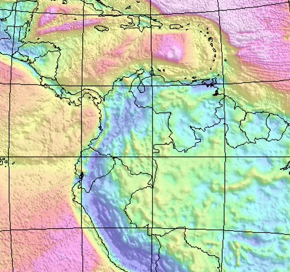
Product Overview
All products are available in ArcGIS, geoTiff and other formats compatible for use in Petrel, Decision Space, Kingdom and other geoscience interpretation software. Deliverables:
- Integrated Free Air and Bouguer gravity maps and interpretation for the Caribbean and northern South America validated.
- Depth to basement map, gravity inversion calibrated with onshore geology, basement penetrations, and seismic interpretation.
- Regional gravity interpretation, including structural trends, basement types, and tectonic blocks.
- Regional gravity transects modelled, structural configuration, sediment cover and crustal thickness.
- Final technical report, detailing methodologies, references, results, and recommendations.
Use Cases of the Products
Gravity inversions are used to define the configuration of the basins, estimate sediment cover thickness, the heat flow, and structural trends. The products should be integrated with other corporate geoscience datasets and used for:
- Identification of the new plays in the explored and underexplored sedimentary basins.
- Prioritization of high-potential areas for licensing and investment.
- Integration with your 2D/3D seismic interpretation and petroleum systems modeling.
- Support for geothermal energy assessments and sustainable exploration of natural resources.
Unique Value Proposition
Gravity measurements have non-unique interpretations without calibration with available geologic information. Our products are built by a team of experts with decades of regional expertise and local geology knowledge. The outputs are calibrated using critically reviewed published seismic interpretation and geologic controls. The team collected more than 40.000 control points to support the Depth to Basement calculations. The outputs were reviewed in the workshops by the team, which included specialists in structural geology, geochemistry, seismic interpretation, plate tectonics, and petroleum geology.
Availability and Contact
This gravity product isavailable under license for companies, government agencies, and consultantsseeking high-quality regional evaluation tools or exploration support. Foraccess, demonstrations, or acquisition inquiries, please contact:
info@u3explore.com
