Project genesis
Caribbean basins have been the subject of recent data acquisition and exploration efforts, largely based on geological models developed in the 1990s before play-based exploration methodologies were developed and tested. The last thirty years were also a time when plate models were developed and improved with the addition of large volumes of geological and geophysical data. The complex deformation history of the Caribbean Basins is in need of an update, utilizing new insights and improved technology.
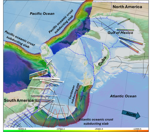
The Caribbean Basins Atlas presents a new integrated model of basin evolution, utilizing a deformable plate model developed by Global Tectonics, results from industry and academic regional studies, recent drilling results, industry and academic publications, and contributions from local experts in Venezuelan, Colombian, and greater Caribbean petroleum geology. U3 Explore regional experts are revising models and play concepts, which are now better constrained by new geologic and geophysical data and recent drilling results. These updates in the tectonic framework underpin depositional system maps and reduce uncertainty in hydrocarbon system characterization.
Moving forward, the Dynamic Basins Atlas will use the deformable plate models of Global Tectonics to update play concepts and integrate the new tectonic framework into Western Caribbean, Peru, and conjugate South Atlantic Margins, which contain other important hydrocarbon-rich basins such as offshore Guyana/Suriname and the conjugate African basins
Knowledge expansion and exploration value
- Basin-centered knowledge from regional experts on petroleum systems.
- Plate model incorporates proprietary gravity inversion for crustal thickness.
- Restored pre-rift terranes.
- Improved source rock distribution maps and petroleum system insights from revised plate model.
- Tectonostratigraphic framework for reservoir distribution and depositional timing on varying crustal types.
- Interplay between extensional basin development, passive margins, and subduction related deformation and their effects on trap formation and modification.
- Play-based geochemical, well penetration, and field databases.
- Hydrocarbon occurrences and geochemical typing tied to the regional model.
- AI-ready, curated information system.
Proprietary sources of information
- Control points for gravity inversions from Dr. Victor Graterol.
- Depth to basement and depth to Moho maps from seismic, gravity, and well data.
- U3D reservoirs and fields database.
- Circum-Caribbean Geochemical analyses from GSI and Craig Shiefelbein.
- Global Tectonics deformable plate model.
- Play-based geochemical analysis, well penetration, and producing field databases.
Key Deliverables
GIS maps
- Free Air, Bouguer and Corrected Bouguer.
- Depth to basement and depth to Moho maps.
- Paleo-crustal thickness, retro-deformed beta, tectonic subsidence, and paleo-basement dip, Paleogeography for key intervals.
- Source rock distribution and hydrocarbon characterization from geochemistry.
- Play fairway maps and descriptions.
Reports
- Companion report summarizing study results.
- Tectonostratigraphic framework with play elements.
- Plate model for proprietary data reconstructions.
For Licensing Information Contact
Kenneth Mohn Mobile Phone:+1-713-485-9696 E-mail: kwmohn123@gmail.com
